Silbury Hill
x-lp-f005735a8a1917 August 1992·Silbury Hill, Wiltshire
Possibly the same formation as: these cross-site pairs are still open in the index review queue.
-
Silbury Hill (Wiltshire)(cc, tier C, score 0.75, rule adjacent_day, pair 51b263f6)
date 1992-08-16 vs 1992-08-17 (delta -1 d); name tokens shared: silbury; county Wiltshire == Wiltshire; country UK (cc_id) == UK (country_field) -
Silbury Hill (Wiltshire)(cc, tier C, score 0.70, rule month_place, pair 99a6eee7)
date 1992-08 vs 1992-08-17 (day/month); name tokens shared: silbury; county Wiltshire == Wiltshire; country UK (cc_id) == UK (country_field) -
Avebury (Wiltshire)(cc, tier C, score 0.60, rule county_only, pair 32edea46)
date 1992-08-17 vs 1992-08-17 (delta +0 d); county Wiltshire == Wiltshire; country UK (cc_id) == UK (country_field)
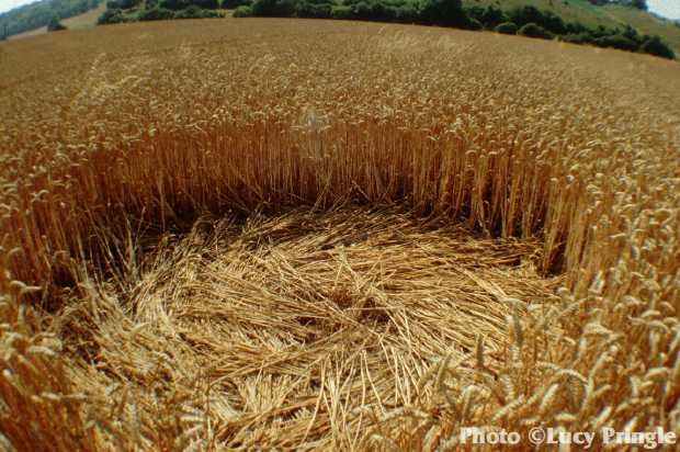
Reported 17 August 1992 at Silbury Hill, Wiltshire. One archive recorded it, so nothing about it can be cross-checked.
The record
- date
- 17 August 1992 (day precision)
- place
- Silbury Hill
Wiltshire
United Kingdom - crop
- not recorded by any source
- size
- not recorded
- recorded by
- lp
- images
- 1 · 1 other
- writing
- nothing was written about this formation on any source
Also called
Nothing else. No other name or place string appears on any source record for this formation.
Where exactly
No coordinate could be resolved from any member record's place name.
Images
1 image(s) on this formation's own source records. Click a tile for the full image; the bytes are fetched when you ask for them and are not stored in this page.
Photographs (1)
| site | kind | credit | basis | caption | size | file | source page |
|---|---|---|---|---|---|---|---|
| lp | other | Lucy Pringle | page credit | The 'Celtic Necklace' formation | 620×412 43.0 KiB image/jpeg |
image ad9f14b359e4 | https://www.cropcirclephotographs.co.uk/photos/1992/uk1992ht.shtml |
Date
17 August 1992, to day precision. What a source records is the day a formation was found and reported.
- reported by
- lp: 17 August 1992
- weekday
- Monday, day 230 of the year, ISO week 34, summer
- sun and moon
- 36.3 days before the September equinox; moon waning gibbous (85% lit), 4.1 days after the full moon (computed at 12:00 UTC; a reported date is a discovery date, not a creation date)
Place
What each source printed, and the coordinate derived from it. No source in this archive publishes a coordinate of its own.
| site | place | county | country | grid ref | what3words | fix |
|---|---|---|---|---|---|---|
| lp | Silbury Hill | Wiltshire | United Kingdom | none |
Crop and size
crop and size not recorded by any source
Source records
What each source published, side by side. A row whose values differ across the sources is marked: the archive prints the disagreement rather than choosing a winner.
| field | lp cropcirclephotographs.co.uk |
|---|---|
| id / slug | silbury-hill-1992 |
| name | Silbury Hill |
| location | Silbury Hill |
| county | Wiltshire |
| country | United Kingdom |
| date reported | 1992-08-17 |
| date precision | day |
| crop | |
| size | |
| diameter (ft) | |
| grid reference | |
| what3words | |
| map link | |
| credits | Lucy Pringle |
| source page | https://www.cropcirclephotographs.co.uk/photos/1992/uk1992ht.shtml |
| link to the entity | singleton decided by none on 2026-09-15 |
| warnings | none |
| record | lp/f005735a8a19e… raw record view: /formation/lp/f005735a8a19ee154ecdb8faad84e916c244d3fb5c6a38f152938364b5c14f76 in the preview app |
Texts
no text documents in the archive for this formation
Claims about this formation
no claim was extracted from a text about this formation
Geometry
no diagram of this formation has been measured
0 diagram file(s) on this page. no diagram of this formation has been measured; run `python -m scraper analysis geometry` to fill this section.
Neighbours
In time
- previous
- Silbury Hill 16 August 1992, Silbury Hill
- next
- Guy 25 August 1992, Guy
- previous in UK
- Silbury Hill 16 August 1992
- next in UK
- Steyning 31 August 1992
- same day
- Avebury (Avebury)
- within 7 days and 25 km
- none, or this formation has no coordinate at place confidence or better
In place
The nearest formations the archive can place.
this formation has no coordinate at place confidence or better, so nothing can be called near it
- same county and year
- Lurkeley Hill 10 May 1992 · Avebury Trusloe 14 May 1992 · Urchfont Hill 17 May 1992 · Market Lavington 18 May 1992 · Avebury Trusloe 20 May 1992 · Amesbury 23 May 1992 · Cherhill 23 May 1992 · Cherhill 24 May 1992 · Lockeridge 24 May 1992 · Lockeridge 25 May 1992 · Lockeridge 25 May 1992 · Alton Barnes 29 May 1992 · Upton Scudamore 30 May 1992 · Alton Barnes 2 June 1992 · Lockeridge 4 June 1992 · West Stowell 4 June 1992 · Wroughton 4 June 1992 · Old Sarum 5 June 1992 · Warminster 7 June 1992 · Waden Hill 8 June 1992 and 92 more
Provenance
- entity built at
- 2026-09-15T21:14:17Z (derived from the link decisions, not from this build)
- index run ids
- none
- reviews applied
- none
- open queue pairs
- 32edea4680d4f756c71a3d677b6063698bbd0eb965f407e4925c2c91a17573a9, 51b263f6e26fb01088222d02d87f005b1a8cdb828f1027fa39fb05488de08a4d, 99a6eee773457d51327ed803555bee7cd86ae5d5f8c98b3e7bf9280530ca265e
- entity record
- index/formations/x-lp-f005735a8a19.json · row in index/manifest.jsonl
- input digests
- entity 6c96c7a39255 · images b70681e78cce · texts 4f53cda18c2b · geo none