Morestead
x-lp-c501c9dba1ebJuly 1995·Morestead, Hampshire
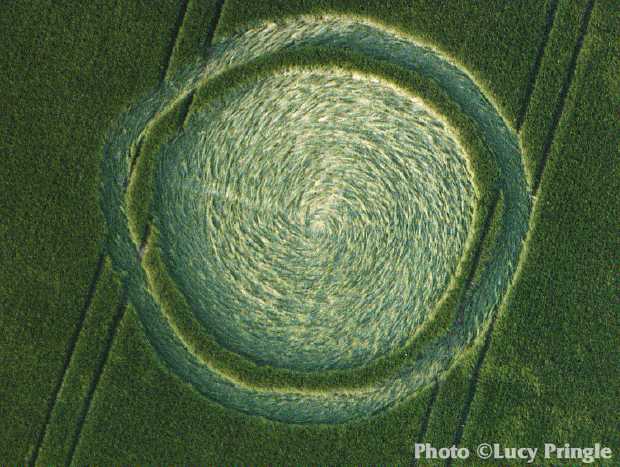
Reported July 1995 at Morestead, Hampshire. One archive recorded it, so nothing about it can be cross-checked.
The record
- date
- July 1995 (month precision)
- place
- Morestead
Hampshire
United Kingdom - crop
- not recorded by any source
- size
- not recorded
- recorded by
- lp
- images
- 1 · 1 other
- writing
- nothing was written about this formation on any source
Also called
Nothing else. No other name or place string appears on any source record for this formation.
Where exactly
No coordinate could be resolved from any member record's place name.
Images
1 image(s) on this formation's own source records. Click a tile for the full image; the bytes are fetched when you ask for them and are not stored in this page.
Photographs (1)
| site | kind | credit | basis | caption | size | file | source page |
|---|---|---|---|---|---|---|---|
| lp | other | Lucy Pringle | page credit | A circle with a ring around it. Both circle and ring contain a small 'bump' at one point in the circumference. | 620×467 44.5 KiB image/jpeg |
image 790728a9695e | https://www.cropcirclephotographs.co.uk/photos/1995/uk1995bm.shtml |
Date
July 1995, to month precision. What a source records is the day a formation was found and reported.
- reported by
- lp: July 1995
Place
What each source printed, and the coordinate derived from it. No source in this archive publishes a coordinate of its own.
| site | place | county | country | grid ref | what3words | fix |
|---|---|---|---|---|---|---|
| lp | Morestead | Hampshire | United Kingdom | none |
Crop and size
crop and size not recorded by any source
Source records
What each source published, side by side. A row whose values differ across the sources is marked: the archive prints the disagreement rather than choosing a winner.
| field | lp cropcirclephotographs.co.uk |
|---|---|
| id / slug | morestead-1995 |
| name | Morestead |
| location | Morestead |
| county | Hampshire |
| country | United Kingdom |
| date reported | 1995-07 |
| date precision | month |
| crop | |
| size | |
| diameter (ft) | |
| grid reference | |
| what3words | |
| map link | |
| credits | Lucy Pringle |
| source page | https://www.cropcirclephotographs.co.uk/photos/1995/uk1995bm.shtml |
| link to the entity | singleton decided by none on 2026-09-15 |
| warnings | none |
| record | lp/c501c9dba1eb1… raw record view: /formation/lp/c501c9dba1eb1b2c0fae4775c19a10eca6ced0b33f627e37f0a8e96bcded621a in the preview app |
Texts
no text documents in the archive for this formation
Claims about this formation
no claim was extracted from a text about this formation
Geometry
no diagram of this formation has been measured
0 diagram file(s) on this page. no diagram of this formation has been measured; run `python -m scraper analysis geometry` to fill this section.
Neighbours
In time
- previous
- Upham 30 June 1995, Upham
- next
- Leconfield 2 July 1995, Leconfield
- previous in UK
- Upham 30 June 1995
- next in UK
- Leconfield 2 July 1995
- same day
- Beusichem (Beusichem) · Brockwood (Brockwood) · Brockwood (Brockwood) · East Meon (East Meon) · Towcester (Towcester) · Binstead (Binstead) · Lilley (Lilley) · Pewsey (Pewsey) · Crewkerne (Crewkerne) · East Meon (East Meon) · Toot Baldon (Toot Baldon) · Waden Hill (Waden Hill) · Amersham (Amersham) · Bayston Hill (Bayston Hill) · Bicester (Bicester) · Compton (Compton) · Culsamond (Culsamond) · East Meon (East Meon) · Fenny Compton (Fenny Compton) · Lake (Lake) · Littleton (Littleton) · Pepperbox Hill (Pepperbox Hill) · Stonehenge (Stonehenge) · Sutton Coldfield (Sutton Coldfield) · Uffcott (Uffcott) · Upper Bentley (Upper Bentley) · Wareham (Wareham) · Warnborough (Warnborough) · West Lavington (West Lavington) · West Meon (West Meon) · Adrian Township (Adrian Township) · Adrian Township (Adrian Township) · Hamden (Hamden) · Pepperbox Hill (Pepperbox Hill) · Dorchester (Dorchester) · Harewood (Harewood) · Henwood (Henwood) · Brockwood Park (Brockwood Park)
- within 7 days and 25 km
- none, or this formation has no coordinate at place confidence or better
In place
The nearest formations the archive can place.
this formation has no coordinate at place confidence or better, so nothing can be called near it
- same county and year
- Goodworth Clatford 22 April 1995 · Muddle Wallop May 1995 · Quidhampton 11 May 1995 · Quidhampton 11 May 1995 · Kings Sombourne 12 May 1995 · Cheriton May 1995 · Kings Worthy May 1995 · Kings Worthy May 1995 · Telegraph Hill June 1995 · Cheesefoot Head 12 June 1995 · Morestead June 1995 · Winchester June 1995 · Danebury Rings 16 June 1995 · Cowdon 17 June 1995 · Cowdon 17 June 1995 · Upham 17 June 1995 · Cheesefoot Head 18 June 1995 · Bishop Sutton 19 June 1995 · Ovington Down 19 June 1995 · Gander Down 20 June 1995 and 42 more
Provenance
- entity built at
- 2026-09-15T21:14:17Z (derived from the link decisions, not from this build)
- index run ids
- none
- reviews applied
- none
- open queue pairs
- none
- entity record
- index/formations/x-lp-c501c9dba1eb.json · row in index/manifest.jsonl
- input digests
- entity 699756813e3b · images 44dd09eea682 · texts 4f53cda18c2b · geo none