Quebec
x-ccc-67f066473b6d31 July 2018·Quebec
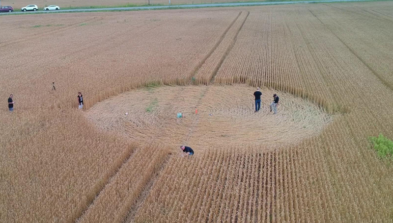
Reported 31 July 2018 at Quebec. One archive recorded it, so nothing about it can be cross-checked.
The record
- date
- 31 July 2018 (day precision)
- place
- Quebec
Canada - crop
- not recorded by any source
- size
- not recorded
- recorded by
- ccc
- images
- 1 · 1 aerial
- writing
- nothing was written about this formation on any source
Also called
Nothing else. No other name or place string appears on any source record for this formation.
Where exactly
- coordinate
- 46.812280, -71.214540
- how it was got
- geonames
place, to within 2,000 m, from the ccc record - on a map
- OpenStreetMap
No source publishes a coordinate for any formation in this archive. Every coordinate here is derived from the place name a source printed, and this page says how precise that makes it rather than rounding it away.
Images
1 image(s) on this formation's own source records. Click a tile for the full image; the bytes are fetched when you ask for them and are not stored in this page.
Photographs (1)
| site | kind | credit | basis | caption | size | file | source page |
|---|---|---|---|---|---|---|---|
| ccc | aerial | cropcircleconnector.com | no credit recorded | 800×455 283.6 KiB image/jpeg |
image 7126e7c2c8a5 | https://www.cropcircleconnector.com/2018/quebec/quebec2018a.html |
Date
31 July 2018, to day precision. What a source records is the day a formation was found and reported.
- reported by
- ccc: 31 July 2018
- weekday
- Tuesday, day 212 of the year, ISO week 31, summer
- sun and moon
- 40.1 days after the June solstice; moon waning gibbous (88% lit), 3.7 days after the full moon (computed at 12:00 UTC; a reported date is a discovery date, not a creation date)
Place
What each source printed, and the coordinate derived from it. No source in this archive publishes a coordinate of its own.
- coordinate
- 46.812280, -71.214540 — place, ±2,000 m, by geonames, from the ccc record
- on a map
- OpenStreetMap
| site | place | county | country | grid ref | what3words | fix |
|---|---|---|---|---|---|---|
| ccc | Canada | 46.812280, -71.214540 place / geonames |
Crop and size
crop and size not recorded by any source
Source records
What each source published, side by side. A row whose values differ across the sources is marked: the archive prints the disagreement rather than choosing a winner.
| field | ccc cropcircleconnector.com |
|---|---|
| id / slug | quebec |
| name | Quebec |
| location | |
| county | |
| country | Canada |
| date reported | 2018-07-31 |
| date precision | day |
| crop | |
| size | |
| diameter (ft) | |
| grid reference | |
| what3words | |
| map link | |
| credits | |
| source page | https://www.cropcircleconnector.com/2018/quebec/quebec2018a.html |
| link to the entity | singleton decided by none on 2026-09-11 |
| warnings | none |
| record | ccc/67f066473b6d… raw record view: /formation/ccc/67f066473b6ddecacaef0a8ab18af6062cbc043327fb6aa831367aef60d49247 in the preview app |
Texts
no text documents in the archive for this formation
Claims about this formation
no claim was extracted from a text about this formation
Geometry
no diagram of this formation has been measured
0 diagram file(s) on this page. no diagram of this formation has been measured; run `python -m scraper analysis geometry` to fill this section.
Neighbours
In time
- previous
- Hackpen Hill 29 July 2018, Hackpen Hill
- next
- Prudentópolis 3 August 2018, Prudentópolis
- previous in CA
- Rocanville 26 September 2011
- next in CA
- none
- same day
- withheld (withheld)
- within 7 days and 25 km
- none, or this formation has no coordinate at place confidence or better
In place
The nearest formations the archive can place.
Notre-Dame-de-Lourdes
71.1 km away, 1990-08 St Cyrille25 June 1971
St Cyrille
133.7 km away, 1971-06-25 St Cyrille25 June 1974
St Cyrille
133.7 km away, 1974-06-25
 RacineJuly 1972
Racine
166.2 km away, 1972-07 St Ambroise de Kildare13 November 2000
St Ambroise de Kildare
198.7 km away, 2000-11-13 St Ambroise De Kildare28 November 2001
St Ambroise De Kildare
198.7 km away, 2001-11-28
- same county and year
- none
Provenance
- entity built at
- 2026-09-11T19:20:39Z (derived from the link decisions, not from this build)
- index run ids
- none
- reviews applied
- none
- open queue pairs
- none
- entity record
- index/formations/x-ccc-67f066473b6d.json · row in index/manifest.jsonl
- input digests
- entity 52b0cdbaec0d · images 83e60d4e240c · texts 4f53cda18c2b · geo a711026e49d7