Roundway Hill
UK20100725_B25 July 2010·Roundway Hill, Wiltshire·wheat
Possibly the same formation as: these cross-site pairs are still open in the index review queue.
-
Alton Barnes (Wiltshire)(cc, tier C, score 0.60, rule county_only, pair a9ef544c)
date 2010-07-25 vs 2010-07-25 (delta +0 d); county Wiltshire == Wiltshire; country UK (cc_id) == UK (uk_county)
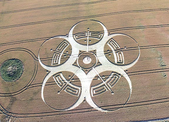
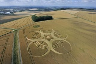
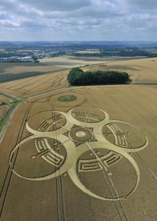
Reported 25 July 2010 in wheat at Roundway Hill, Wiltshire. Two archives recorded it, and they give the same date.
The record
- date
- 25 July 2010 (day precision)
- place
- Roundway Hill
Wiltshire
England - crop
- wheat
- size
- not recorded
- recorded by
- cc lp
- images
- 6 on the record, 6 attached · 2 diagram, 1 aerial, 3 other
- writing
- nothing was written about this formation on any source
Also called
Roundway Hill, nr Devizes
Canonical name from the cropcirclecenter.com name; the rest are what the other source records print for the same formation.
Where exactly
- coordinate
- 51.368040, -1.980817
- how it was got
- os open names
place, to within 2,000 m, from the cc record - on a map
- OpenStreetMap
No source publishes a coordinate for any formation in this archive. Every coordinate here is derived from the place name a source printed, and this page says how precise that makes it rather than rounding it away.
Images
6 image(s) on this formation's own source records, and 6 more on 6 attached record(s) below. Click a tile for the full image; the bytes are fetched when you ask for them and are not stored in this page.
Diagrams (2)
 diagram
cropcirclecenter.com / Bertold Zugelder site default
diagram
cropcirclecenter.com / Bertold Zugelder site default
diagram
cropcirclecenter.com / Bertold Zugelder site default
diagram
cropcirclecenter.com / Bertold Zugelder site default
| site | kind | credit | basis | caption | size | file | source page |
|---|---|---|---|---|---|---|---|
| cc | diagram | cropcirclecenter.com / Bertold Zugelder | site default | crop circle at Roundway Hill | July 25 2010 | 575×415 68.2 KiB image/jpeg |
image c5d0ce4dcff9 | https://www.cropcirclecenter.com/ccdata/2010/07/25/UK20100725_B.html |
| cc | diagram | cropcirclecenter.com / Bertold Zugelder | site default | 575×415 68.2 KiB image/jpeg |
image c5d0ce4dcff9 | https://www.cropcirclecenter.com/date/2010/201007.html |
Photographs (4)
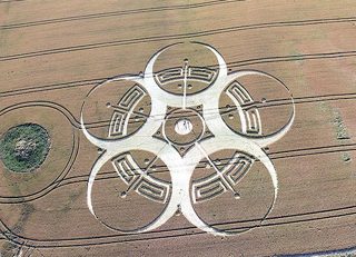 aerial
John Montgomery image credit
aerial
John Montgomery image credit
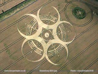 other
Lucy Pringle page credit
other
Lucy Pringle page credit
 other
Lucy Pringle page credit
other
Lucy Pringle page credit
 other
Lucy Pringle page credit
other
Lucy Pringle page credit
| site | kind | credit | basis | caption | size | file | source page |
|---|---|---|---|---|---|---|---|
| cc | aerial | John Montgomery | image credit | crop circle at Roundway Hill | July 25 2010 | 575×415 88.1 KiB image/jpeg |
image eb6fcff45ed1 | https://www.cropcirclecenter.com/ccdata/2010/07/25/UK20100725_B.html |
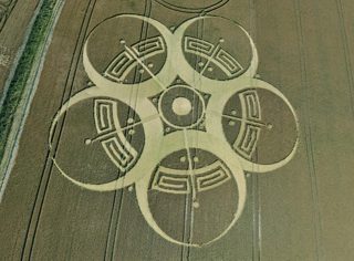
| lp | other | Lucy Pringle | page credit | An outer five pointed flower pattern overlapping a `Greek Key` pattern with a central circle surrounded by a pentacle. | 800×611 97.7 KiB image/jpeg |
image 2df418701873 | https://www.cropcirclephotographs.co.uk/photos/2010/roundway-hill-cropcircle-2010.shtml |
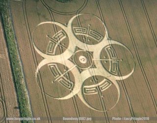
| lp | other | Lucy Pringle | page credit | An outer five pointed flower pattern overlapping a `Greek Key` pattern with a central circle surrounded by a pentacle. | 800×624 90.8 KiB image/jpeg |
image 5fbee779f274 | https://www.cropcirclephotographs.co.uk/photos/2010/roundway-hill-cropcircle-2010.shtml |
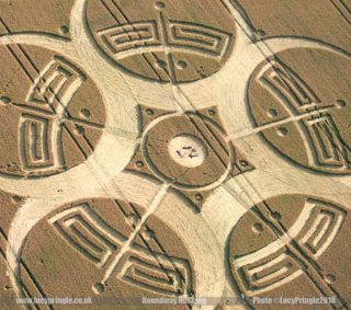
| lp | other | Lucy Pringle | page credit | An outer five pointed flower pattern overlapping a `Greek Key` pattern with a central circle surrounded by a pentacle. | 800×707 125.0 KiB image/jpeg |
image f2d2a32e6580 | https://www.cropcirclephotographs.co.uk/photos/2010/roundway-hill-cropcircle-2010.shtml |
Attached photographs (6)
inferred link These pictures did not come with a source record of this formation. Each one is a single-photograph archive entry whose own date and place the index matched to this formation; nothing about the formation itself comes from them. The rule, the score and the evidence are printed with each record so the link can be checked, and the credit stays with the photograph.
Roundway Hill near Devizes, Wiltshire | 25th July 2010 | Wheat L2
tt temporarytemples.co.uk · archive_image · 25 July 2010 ·
matched on date and place by the index (not confirmed by hand) · rule attach, tier B, score 0.90 ·
pair a49cd9ee458d · decided 2026-09-15T03:03:25Z
- attachment: tt archive_image roundway-hill-near-devizes-wiltshire-25th-july-2010-wheat-l2
- date 2010-07-25 vs 2010-07-25 (delta +0 d)
- name tokens shared: roundway
- alias devizes ~ roundway (seed)
- county Wiltshire == Wiltshire
- country UK (uk_county) == UK (cc_id)
- crop wheat == wheat
- the only entity the photograph's date and place fit (UK20100725_B)
| site | kind | credit | basis | caption | size | file | source page |
|---|---|---|---|---|---|---|---|
| tt | aerial | Steve Alexander / Temporary Temples | site default | Roundway Hill near Devizes, Wiltshire | 25th July 2010 | Wheat L2 | 800×533 122.5 KiB image/jpeg |
image e068389fc9ab | https://temporarytemples.co.uk/crop-circles/2010-crop-circles |
Roundway Hill near Devizes, Wiltshire | 25th July 2010 | Wheat L
tt temporarytemples.co.uk · archive_image · 25 July 2010 ·
matched on date and place by the index (not confirmed by hand) · rule attach, tier B, score 0.90 ·
pair 20cf02c5d05c · decided 2026-09-15T03:03:25Z
- attachment: tt archive_image roundway-hill-near-devizes-wiltshire-25th-july-2010-wheat-l
- date 2010-07-25 vs 2010-07-25 (delta +0 d)
- name tokens shared: roundway
- alias devizes ~ roundway (seed)
- county Wiltshire == Wiltshire
- country UK (uk_county) == UK (cc_id)
- crop wheat == wheat
- the only entity the photograph's date and place fit (UK20100725_B)
| site | kind | credit | basis | caption | size | file | source page |
|---|---|---|---|---|---|---|---|
| tt | aerial | Steve Alexander / Temporary Temples | site default | Roundway Hill near Devizes, Wiltshire | 25th July 2010 | Wheat L | 571×800 137.9 KiB image/jpeg |
image 2538f70e7ae2 | https://temporarytemples.co.uk/crop-circles/2010-crop-circles |
Roundway Hill near Devizes, Wiltshire | 25th July 2010 | Wheat CB
tt temporarytemples.co.uk · archive_image · 25 July 2010 ·
matched on date and place by the index (not confirmed by hand) · rule attach, tier B, score 0.90 ·
pair fff975720d0b · decided 2026-09-15T03:03:25Z
- attachment: tt archive_image roundway-hill-near-devizes-wiltshire-25th-july-2010-wheat-cb
- date 2010-07-25 vs 2010-07-25 (delta +0 d)
- name tokens shared: roundway
- alias devizes ~ roundway (seed)
- county Wiltshire == Wiltshire
- country UK (uk_county) == UK (cc_id)
- crop wheat == wheat
- the only entity the photograph's date and place fit (UK20100725_B)
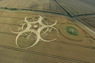
| site | kind | credit | basis | caption | size | file | source page |
|---|---|---|---|---|---|---|---|
| tt | aerial | Steve Alexander / Temporary Temples | site default | Roundway Hill near Devizes, Wiltshire | 25th July 2010 | Wheat CB | 800×533 142.5 KiB image/jpeg |
image dcbee4e404c1 | https://temporarytemples.co.uk/crop-circles/2010-crop-circles |
Roundway Hill near Devizes, Wiltshire | 25th July 2010 | Wheat OH
tt temporarytemples.co.uk · archive_image · 25 July 2010 ·
matched on date and place by the index (not confirmed by hand) · rule attach, tier B, score 0.90 ·
pair ff0ac65c41b1 · decided 2026-09-15T03:03:25Z
- attachment: tt archive_image roundway-hill-near-devizes-wiltshire-25th-july-2010-wheat-oh
- date 2010-07-25 vs 2010-07-25 (delta +0 d)
- name tokens shared: roundway
- alias devizes ~ roundway (seed)
- county Wiltshire == Wiltshire
- country UK (uk_county) == UK (cc_id)
- crop wheat == wheat
- the only entity the photograph's date and place fit (UK20100725_B)
| site | kind | credit | basis | caption | size | file | source page |
|---|---|---|---|---|---|---|---|
| tt | aerial | Steve Alexander / Temporary Temples | site default | Roundway Hill near Devizes, Wiltshire | 25th July 2010 | Wheat OH | 800×589 178.5 KiB image/jpeg |
image 7bd061952c49 | https://temporarytemples.co.uk/crop-circles/2010-crop-circles |
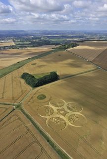
Roundway Hill near Devizes, Wiltshire | 25th July 2010 | Wheat OV
tt temporarytemples.co.uk · archive_image · 25 July 2010 ·
matched on date and place by the index (not confirmed by hand) · rule attach, tier B, score 0.90 ·
pair 9339648a74f3 · decided 2026-09-15T03:03:25Z
- attachment: tt archive_image roundway-hill-near-devizes-wiltshire-25th-july-2010-wheat-ov
- date 2010-07-25 vs 2010-07-25 (delta +0 d)
- name tokens shared: roundway
- alias devizes ~ roundway (seed)
- county Wiltshire == Wiltshire
- country UK (uk_county) == UK (cc_id)
- crop wheat == wheat
- the only entity the photograph's date and place fit (UK20100725_B)
| site | kind | credit | basis | caption | size | file | source page |
|---|---|---|---|---|---|---|---|
| tt | aerial | Steve Alexander / Temporary Temples | site default | Roundway Hill near Devizes, Wiltshire | 25th July 2010 | Wheat OV | 541×800 120.8 KiB image/jpeg |
image 1a3258a27dc4 | https://temporarytemples.co.uk/crop-circles/2010-crop-circles |
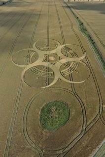
Roundway Hill near Devizes, Wiltshire | 25th July 2010 | Wheat CB2
tt temporarytemples.co.uk · archive_image · 25 July 2010 ·
matched on date and place by the index (not confirmed by hand) · rule attach, tier B, score 0.90 ·
pair c366548ed400 · decided 2026-09-15T03:03:25Z
- attachment: tt archive_image roundway-hill-near-devizes-wiltshire-25th-july-2010-wheat-cb2
- date 2010-07-25 vs 2010-07-25 (delta +0 d)
- name tokens shared: roundway
- alias devizes ~ roundway (seed)
- county Wiltshire == Wiltshire
- country UK (uk_county) == UK (cc_id)
- crop wheat == wheat
- the only entity the photograph's date and place fit (UK20100725_B)
| site | kind | credit | basis | caption | size | file | source page |
|---|---|---|---|---|---|---|---|
| tt | aerial | Steve Alexander / Temporary Temples | site default | Roundway Hill near Devizes, Wiltshire | 25th July 2010 | Wheat CB2 | 533×800 135.6 KiB image/jpeg |
image d87484feb6fd | https://temporarytemples.co.uk/crop-circles/2010-crop-circles |
Date
25 July 2010, to day precision. What a source records is the day a formation was found and reported.
- reported by
- cc: 25 July 2010 lp: 25 July 2010
- weekday
- Sunday, day 206 of the year, ISO week 29, summer
- sun and moon
- 34.0 days after the June solstice; moon full (100% lit), 0.6 days before the full moon (computed at 12:00 UTC; a reported date is a discovery date, not a creation date)
Place
What each source printed, and the coordinate derived from it. No source in this archive publishes a coordinate of its own.
- coordinate
- 51.368040, -1.980817 — place, ±2,000 m, by os_open_names, from the cc record
- on a map
- OpenStreetMap
| site | place | county | country | grid ref | what3words | fix |
|---|---|---|---|---|---|---|
| cc | Wiltshire | England | 51.368040, -1.980817 place / os_open_names | |||
| lp | Roundway Hill, nr Devizes | Wiltshire | none |
Crop and size
- crop
- wheat (cc: wheat, lp: —)
- diameter
- not recorded by any source
- size as written
- not recorded
Source records
What each source published, side by side. A row whose values differ across the sources is marked: the archive prints the disagreement rather than choosing a winner.
| field | cc cropcirclecenter.com | lp cropcirclephotographs.co.uk |
|---|---|---|
| id / slug differs | UK20100725_B | roundway-hill-2010 |
| name | Roundway Hill | Roundway Hill |
| location | Roundway Hill, nr Devizes | |
| county | Wiltshire | Wiltshire |
| country | England | |
| date reported | 2010-07-25 | 2010-07-25 |
| date precision | day | day |
| crop | wheat | |
| size | ||
| diameter (ft) | ||
| grid reference | ||
| what3words | ||
| map link | ||
| credits differs | John Montgomery, cropcirclecenter.com / Bertold Zugelder | Lucy Pringle |
| source page differs | https://www.cropcirclecenter.com/date/2010/201007.html | https://www.cropcirclephotographs.co.uk/photos/2010/roundway-hill-cropcircle-2010.shtml |
| link to the entity | rule Bscore 0.90 decided by rule on 2026-09-15 date 2010-07-25 vs 2010-07-25 (delta +0 d); name tokens shared: roundway; alias devizes ~ roundway (seed); county Wiltshire == Wiltshire; country UK (cc_id) == UK (uk_county) |
rule Bscore 0.90 decided by rule on 2026-09-15 date 2010-07-25 vs 2010-07-25 (delta +0 d); name tokens shared: roundway; alias devizes ~ roundway (seed); county Wiltshire == Wiltshire; country UK (cc_id) == UK (uk_county) |
| warnings | none | none |
| record | cc/aee04a19bbfbd… raw record view: /formation/cc/aee04a19bbfbd885e5b8a8ee06fa118541978672d6e77cef174586821504060d in the preview app |
lp/98a9beeb88315… raw record view: /formation/lp/98a9beeb8831527ff239f08d7f6fc7318a8be4575e7f18d712844085212e172e in the preview app |
Texts
no text documents in the archive for this formation
Claims about this formation
0 claim(s) extracted by lexicon from the texts above. A claim row is a record of what an author wrote, with the sentence verbatim. It is not evidence about the formation, and nothing here is tested on this page.
Texts about other formations that refer to this one:
- “Roundway Hill on July 25, 2010” ← Long Wood· Red Collie (Dr. Horace R. Drew)
Geometry
2 diagram file(s) on this page. measured from the diagram itself, and experimental: the extractor's rotational order is right on 88.8 % of a 200-diagram hand-labelled set against a gate of 90 %, so read a number here beside the picture rather than instead of it.
| diagram | rotational symmetry | elements | rings | mirror | fill |
|---|---|---|---|---|---|
| cc c5d0ce4d | ≈ 5-fold score 0.946 | 22 | 8 | 0.831 | 0.376 |
Experimental, and marked ≈ wherever it appears. These numbers are read off a drawing, not off the field: the extractor's rotational order agrees with a hand-labelled set on 88.8 per cent of 200 diagrams against a gate of 90 per cent, its element count is within one on 97.5 per cent, and its ring count is not calibrated at all. Nothing in the analysis tree is derived from the rotational order while that gate is unmet.
Diagrams that look like these: cc c5d0ce4d— the nearest by perceptual hash. The whole archive is browsable by shape in the shape section, and this formation's own diagrams go straight into that grid: show them in the grid.
Neighbours
In time
- previous
- Le Vigen 24 July 2010, Le Vigen
- next
- Alton Barnes 26 July 2010, Alton Barnes
- previous in UK
- Bishopstone 21 July 2010
- next in UK
- Alton Barnes 26 July 2010
- same day
- Alton Barnes (Alton Barnes) · The White Horse (The White Horse)
- within 7 days and 25 km
- Milk Hill 28 July 2010, 9.0 km away, 3 day(s) apart · Alton Barnes 25 July 2010, 9.1 km away, 0 day(s) apart · Alton Barnes 26 July 2010, 9.1 km away, 1 day(s) apart · Alton Barnes 29 July 2010, 9.1 km away, 4 day(s) apart · Alton Barnes 31 July 2010, 9.1 km away, 6 day(s) apart · Silbury Hill 28 July 2010, 10.1 km away, 3 day(s) apart · Westbury 1 August 2010, 18.5 km away, 7 day(s) apart · Chalk Pit 27 July 2010, 21.9 km away, 2 day(s) apart · Windmill Hill 27 July 2010, 22.5 km away, 2 day(s) apart
In place
The nearest formations the archive can place.
 Roundway Devizes28 June 1991
Roundway Devizes
0 m away, 1991-06-28
 Roundway Devizes24 July 1992
Roundway Devizes
0 m away, 1992-07-24
 Roundway Devizes21 July 1995
Roundway Devizes
0 m away, 1995-07-21
 Roundway Devizes25 July 1995
Roundway Devizes
0 m away, 1995-07-25
 Roundway DevizesAugust 1995
Roundway Devizes
0 m away, 1995-08
 Roundway Devizes16 July 1996
Roundway Devizes
0 m away, 1996-07-16
- same county and year
- Old Sarum 5 May 2010 · Stonehenge 9 May 2010 · Yarnbury Castle 16 May 2010 · Yarnbury Castle 16 May 2010 · Wilton 22 May 2010 · Yatesbury 27 May 2010 · Silbury Hill 31 May 2010 · Westwoods 31 May 2010 · Liddington Castle 2 June 2010 · Codford St Peter 3 June 2010 · Chirton Bottom 16 June 2010 · Oare 21 June 2010 · Savernake Forest 23 June 2010 · Mere 25 June 2010 · Chisbury 3 July 2010 · Mere 5 July 2010 · Cley Hill 9 July 2010 · Vernham Dean 17 July 2010 · Alton Barnes 25 July 2010 · Alton Barnes 26 July 2010 and 31 more
Provenance
- entity built at
- 2026-09-15T21:14:17Z (derived from the link decisions, not from this build)
- index run ids
- 20260915T030325Z-index-build, 20260915T211417Z-index-build
- reviews applied
- none
- open queue pairs
- a9ef544cbb54bf762790cdd4dd5c1f9c5ceb131054b306cea93ec65a0ebe8ebf
- entity record
- index/formations/UK20100725_B.json · row in index/manifest.jsonl
- input digests
- entity 03ccd85e7c94 · images 5e9bcab95b30 · attachments 354e75acfe17 · texts 4f53cda18c2b · geo b4f7e7928222