
Reported 30 July 2003 in wheat at Hensall. One archive recorded it, so nothing about it can be cross-checked.
The record
- date
- 30 July 2003 day precision
- place
- Hensall, Canada no other name or place string on any source record · name from the cropcirclecenter.com name
- crop
- wheat
- size
- 233 ft (71.0 m) acrossas written: 71 m | 233 ft
- recorded by
- cc · cropcirclecenter.com
- images
- 1 · 1 diagram
- writing
- nothing was written about this formation on any source
Where exactly
- coordinate
- 43.433390, -81.499760
- how it was got
- geonames — place, to within 2,000 m, from the cc record
- on a map
- OpenStreetMap
No source publishes a coordinate for any formation in this archive. Every coordinate here is derived from the place name a source printed, and this page says how precise that makes it rather than rounding it away.
Images
1 image(s) on this formation's own source records. Click a tile for the full image; the bytes are fetched when you ask for them and are not stored in this page.
Diagrams (1)
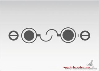
| site | kind | credit | basis | caption | size | file | source page |
|---|---|---|---|---|---|---|---|
| cc | diagram | cropcirclecenter.com / Bertold Zugelder | site default | 575×415 46.2 KiB image/jpeg |
image c2919e0132ad | https://www.cropcirclecenter.com/date/2003/200307.html |
Date
30 July 2003, to day precision. What a source records is the day a formation was found and reported.
- reported by
- cc: 30 July 2003
- weekday
- Wednesday, day 211 of the year, ISO week 31, summer
- sun and moon
- 38.7 days after the June solstice; moon waxing crescent (2% lit), 12.7 days before the full moon (computed at 12:00 UTC; a reported date is a discovery date, not a creation date)
Place
What each source printed, and the coordinate derived from it. No source in this archive publishes a coordinate of its own.
- coordinate
- 43.433390, -81.499760 — place, ±2,000 m, by geonames, from the cc record
- on a map
- OpenStreetMap
| site | place | county | country | grid ref | what3words | fix |
|---|---|---|---|---|---|---|
| cc | Ontario | Canada | 43.433390, -81.499760 place / geonames |
Crop and size
- crop
- wheat (cc: wheat)
- diameter
- 233 ft (71.0 m)
- size as written
- 71 m | 233 ft
Source records
What each source published, side by side. A row whose values differ across the sources is marked: the archive prints the disagreement rather than choosing a winner.
| field | cc cropcirclecenter.com |
|---|---|
| id / slug | CA20030730_A |
| name | Hensall |
| location | |
| county | Ontario |
| country | Canada |
| date reported | 2003-07-30 |
| date precision | day |
| crop | wheat |
| size | 71 m | 233 ft |
| diameter (ft) | 233 |
| grid reference | |
| what3words | |
| map link | |
| credits | cropcirclecenter.com / Bertold Zugelder |
| source page | https://www.cropcirclecenter.com/date/2003/200307.html |
| link to the entity | singleton decided by none on 2026-09-11 |
| warnings | no_formation_page |
| record | cc/0d7756dd06688… raw record view: /formation/cc/0d7756dd0668820c458e188bb5c5ad10a90bd993de819931c0d9cbb624517e6d in the preview app |
Texts
no text documents in the archive for this formation
Claims about this formation
no claim was extracted from a text about this formation
Geometry
1 diagram file(s) on this page. measured from the diagram itself, and experimental: the extractor's rotational order is right on 88.8 % of a 200-diagram hand-labelled set against a gate of 90 %, so read a number here beside the picture rather than instead of it.
| diagram | rotational symmetry | elements | rings | mirror | fill |
|---|---|---|---|---|---|
| cc c2919e01 | ≈ 2-fold score 0.905 | 7 | 0 | 0.94 | 0.0837 |
Experimental, and marked ≈ wherever it appears. These numbers are read off a drawing, not off the field: the extractor's rotational order agrees with a hand-labelled set on 88.8 per cent of 200 diagrams against a gate of 90 per cent, its element count is within one on 97.5 per cent, and its ring count is not calibrated at all. Nothing in the analysis tree is derived from the rotational order while that gate is unmet.
Diagrams that look like these: cc c2919e01— the nearest by perceptual hash. The whole archive is browsable by shape in the shape section, and this formation's own diagrams go straight into that grid: show them in the grid.
Neighbours
In time
- previous
- Marion Township 29 July 2003, Marion Township
- next
- West Overton 31 July 2003, West Overton
- previous in CA
- Stewarttown 23 July 2003
- next in CA
- Cranbrook 6 August 2003
- same day
- Borsov nad Vitavou (Borsov nad Vitavou) · Nederasselt (Nederasselt)
- within 7 days and 25 km
- none, or this formation has no coordinate at place confidence or better
In place
The nearest formations the archive can place.
Exeter
10.1 km away, 2002-07-14 Grand Bend1970
Grand Bend
24.0 km away, 1970 Grand BendSeptember 1976
Grand Bend
24.0 km away, 1976-09
 Grand Bend21 July 2004
Grand Bend
24.0 km away, 2004-07-21
 Holmesville11 July 2008
Holmesville
25.0 km away, 2008-07-11
 Londesborough1 October 2007
Londesborough
29.6 km away, 2007-10-01
- same county and year
- none
Provenance
- entity built at
- 2026-09-11T19:20:39Z (derived from the link decisions, not from this build)
- index run ids
- none
- reviews applied
- none
- open queue pairs
- none
- entity record
- index/formations/CA20030730_A.json · row in index/manifest.jsonl
- input digests
- entity dd42c944b0a3 · images 9bbce3c9ebd5 · texts 4f53cda18c2b · geo e3d2b52935b5